During my research in 1988 for potential areas to map,
I continued to come across black and white photos
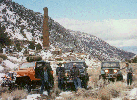
of the smelting tower at Panamint City. The photos
showed a brick tower standing 65 feet tall and
connecting ovens. Some figures estimate the
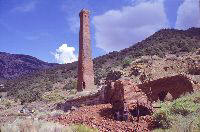
silver boom town supported as many as 5,000
miners. Main Street was one mile long and
rose 1,000 feet before reaching the mill site.
Six general stores, twelve saloons, a bank,
brewery, meat market, and the office of The
Panamint News were among the many buildings
that lined main street. It was the history and
those black and white photos that lured me into
the Panamint Mountains.
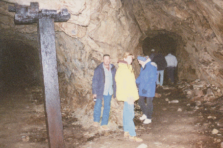
The small town of Ballarat sits at the foot of the Panamint Mountains and is the gateway to several canyons including Surprise Canyon. By the time I arrived in Ballarat in late 1989 "Seldom Seen Slim" had been replaced by a new town Sheriff, Mayor, and Caretaker by the name of Don Connolly. At first he seemed to take his caretaker role a little too seriously. He was quiet and you always knew he was observing you. For some unknown reason we just started calling him "Ballarat Don." Over the past five years as more visitors came to Ballarat, Don began to loosen up. Today he operates a General Store, sells ice, monitors channel 9 on the CB radio and best of all he sells Sidekick maps. On several occasions Don was able to relay emergency information into the town of Panamint Springs where they have phone service and could summon help.
Originally I allocated three trips into the
area to verify the topographical data
that I had digitized into my compute
r for a map of the area. The original
plan allowed one weekend to drive
up Surprise Canyon into Panamint
City and explore routes in the
surrounding canyons at the top
of Surprise Canyon. I got a surprise
with a capital "S."
On the first trip into the old town of Ballarat
I was greeted with a sign that read
"Surprise Canyon washed out." How
could this be? The road was listed as
open on the BLM's Desert Access
Guide (map). My first thought was
that "one man's impossibility is just
another off-road trip" but this time
the sign was true: I walked up the
waterfalls and witnessed the road
damage done by flash flooding and
it was incredible!
After returning home, I continued working on a map extending it south to pick up Gohler Wash. Surprise Canyon and the route to Panamint City was left on the map, even though the route was probably impassable at that time. After publishing the Panamint Mountains Map, I kept thinking about the washed out road
to Panamint City. First I convinced myself
it might be passable to those who
considered themselves extreme
hard-core 4-wheelers. Next I needed
to convince a club to get excited
about the challenge. It just so
happened that I knew of a group
that might take the challenge: the
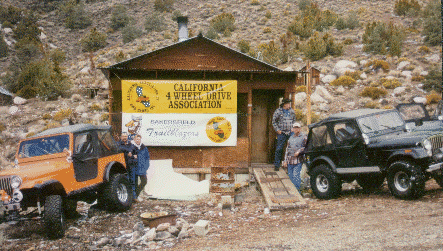
Bakersfield Trail Blazers. There
are many hard-core clubs in the
state, however this club was
already involved with the
Panamint Valley Days Event/Trail Ride and were familiar with the canyon. So with the help of Don Ferguson, a friend, I enlisted the Bakersfield Trail Blazers to meet the challenge.
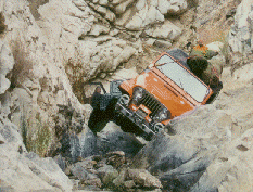
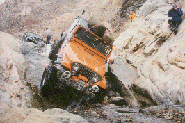
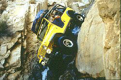
Originally I thought ramps could be placed at each waterfall and each vehicle could drive up and over them one at a time. But once the ramp slipped off the first waterfall from the weight of
somebody walking on it, no one would
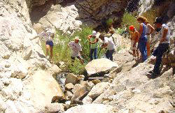
drive their vehicle on it. So with over
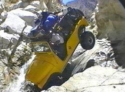
30 people, we began stacking rocks
and moving the vehicles up the
canyon one section at a time. By
the end of the first weekend we
had managed to work our way over
four waterfalls. From the place we
turned around there were only
three waterfalls remaining to fight
our way over. That was just enough
to entice the Bakersfield Trail Blazers
back to finish the trail repair. I did keep m
y thoughts to myself—I wasn't sure whether we could keep the vehicles from rolling over on the end of the winch cable at the last waterfalls.
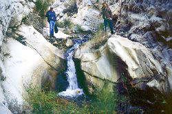
From area maps you can see that Sourdough Canyon and Thompson Canyon add to the water collected by 6 miles of Surprise Canyon before reaching the 30-50 foot wide mouth of the canyon. This situation combined with the mud splatters on the canyon walls 40 feet above the ground and the fact that the town of Panamint City was actually wiped out by flash flood several times, will explain the devastation done to this road. At the bottom of a few waterfalls the holes were deep enough to hide a complete flat fender.
Just to add more problems, an unfriendly miner lived in an old cabin at the mouth of the canyon. The old man, George, and his grown son, Rocky, were like trolls who were territorial and came out to chase you away from this public right-of-way. On one occasion the son fired a shot over our heads and on another trip the old man picked up a rock and chased a guy who was video-taping. They also had planted boards with nails sticking up and buried them halfway in the sand. Even after the road was repaired (sort of) and 4-wheelers started visiting Panamint City, the miner continued to harass four wheelers. But the final straw happened during the Panamint Valley Days Event when the son greased the face of large rock in an attempt to wreck some of the vehicles returning from Panamint City. The BLM ticketed and prosecuted him for obstructing a public right-of-way (road). Today both men still live at the mouth of Surprise Canyon but are seldom seen.
Once the canyon was declared passable I returned to the Panamint Mountains to produce a video, reprinted my Sidekick Map and have shown the area to many groups including CNN and the BBS News (England). Although Senate Bill 21 limited some access in the Panamint Mountains, Surprise Canyon, Pleasant Canyon and Gohler Wash are still open to motorized travel. The area is a great four-wheeling experience for anyone who visits it.
I'll take credit for deciding Surprise Canyon was passable and motivating folks to keep working, but we should all extend our thanks to the Bakersfield TrailBlazers and Don Ferguson who kept another route open to the public. (end)